Esri’s Customers Prove CIOs Are Getting Half the Story Without GIS
Esri’s user conference showed geographic information systems (GIS) connecting street sweepers, Italian railways, and barley farms to enterprise data. CIOs who leave GIS out of their AI and data strategy are working from half the picture.
Street sweepers, Italian rail platforms, and barley fields don’t seem to belong in a conversation about artificial intelligence strategy. Esri’s user conference argued otherwise: a physical asset or process gets tied to a location, that location gets tied to data, and only then does the data become something an organization can act on. That is what GIS is: the layer connecting the physical world to everything an enterprise already knows. Without it, a CIO is working from half the picture, sometimes less.
The conference was a referendum on where GIS fits next
Esri held its annual User Conference in San Diego, July 12 through 17, with the theme “GIS: Creating a More Intelligent World.” Founder and President Jack Dangermond told the plenary crowd – by his own estimate fifteen to sixteen thousand people in the room – that attendees had traveled from more than 117 countries, and many more were watching online.
Esri built this on consulting work, not software sales
Esri’s own account of its history shapes how the company talks about GIS today. It was founded in 1969 by Jack and Laura Dangermond out of a Harvard lab as a land-use consulting practice; the software came later, once the tools built for that consulting work turned out to be worth selling on their own.
Esri says it remains privately held and self-funded, with roughly 6,000 employees and headquarters in Redlands, California, and that it reinvests 32% of its revenue into research and development. Rather than franchise resellers, it operates through locally owned distributor affiliates in every country it serves. Esri says roughly 700,000 organizations use its technology worldwide and that its ArcGIS Online platform alone serves four to five billion maps a day, a figure that does not include on-premises deployments the company says it cannot measure.

The physical world doesn’t care about your org chart
The customers on stage gave the clearest evidence for the physical-to-data argument.
Sweeping Corporation of America, the largest street sweeping company in the country by its own account, sweeps more than 6 million miles a year across 1,700 trucks, 22 states, and 70 operating branches, built from 46 separate acquisitions since 2020. Its problem was trust: Cities and commercial customers could not verify that a contracted mile of sweeping had happened, and a fragmented, price-driven industry gave operators an incentive to shortchange the job without getting caught. Its fix, described by its own team on stage, was to connect its fleet through telematics and camera hardware, route scheduling through Salesforce Field Service, and use Esri as what its team called the system of record for evidence: verified sweeping visualized on a map and shared with the customer. GIS turned that tracking into proof, distinguishing a missed block from one blocked by an illegally parked car.
Rete Ferroviaria Italiana (RFI), Italy’s national rail infrastructure operator, showed the same pattern at a different scale. RFI manages roughly 10,000 miles of network, nearly 3 million passengers, and 9,000 trains a day, according to its own presenters. The company used location intelligence to classify every station into one of six categories based on what surrounds it, tourism, education, transit, and so on, and used that classification to set investment and staffing levels station by station.
It then turned inward: In under two years, RFI says it mapped the interior of more than 2,000 stations, 75 million square feet of indoor space, 100,000 rooms, and 250,000 individual assets down to benches and fire extinguishers, calling it the largest indoor asset-mapping project completed to date. The payoff is direct: real-time maintenance dashboards and an accessibility view showing exactly which routes through a station a passenger with reduced mobility can use.
The City of Allentown, Pennsylvania’s third-largest city, made the opposite point: An organization does not need RFI’s budget for GIS to matter. Its entire GIS function is two people, who built the city’s 311 nonemergency reporting system out of an Esri solutions template rather than custom code, then extended the same underlying data into field inspections of things like street signs, photographed and geotagged from a phone. Two staff members now run infrastructure management, public safety mapping, and community services reporting off one shared data foundation.
Other use cases during the week applied the same logic across industries: An Idaho barley cooperative that supplies barley for roughly half of all beer sold in the US tracked soil health and yield by field over multiple years; a regional beer distributor geofenced delivery trucks to target marketing by neighborhood; and an energy utility with more than 70 gigawatts of generating capacity managed its physical grid much as RFI manages a rail network. None of these are software companies. All of them run on physical assets that only become manageable once they are tied to a place.
AI still can’t find its way around without GIS
Esri’s artificial intelligence pitch builds on the same pattern. Large language models can reason over text, but they do not understand where things are or how places relate to one another. Esri’s argument, repeated across multiple sessions, was that geography provides the missing context that makes an AI answer grounded rather than merely plausible.
That argument came with an uncomfortable admission. One Esri product lead described business units connecting AI agents directly to spreadsheet exports from GIS teams, using CSV files handed over on request because no one brought GIS into the AI planning process.
Esri’s technical answer is a Model Context Protocol connection that lets an AI agent query ArcGIS Enterprise directly, search a portal, retrieve layer metadata, and run spatial queries, such as finding every asset within a defined distance of a location, instead of relying on a static export. But the technical fix does not close the organizational gap. GIS still has to be in the room for that connection to be built in the first place.
Esri’s own models do the unglamorous work
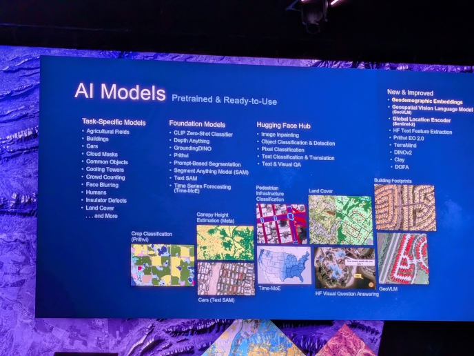
On the AI models’ side, Esri’s message is narrower and more credible. Its Living Atlas now includes more than 100 pretrained models, mostly designed for specific tasks such as extracting building footprints, classifying land cover, or detecting changes across images. Esri has added foundation models to that library, including a geodemographic embeddings layer that reduces more than 5,000 census, housing, and environmental variables for each location into about 250 numbers, and a preview of GeoVLM, a multimodal model designed to answer questions about remote sensing imagery.
The single best proof of what this buys an organization came from the US Census Bureau. Building the address list for a census used to take more than two years of office and field work. Using Esri’s pretrained imagery models to extract building footprints and roads, fine-tuned against samples its own staff had reviewed by hand, the Bureau says it now completes that same list in about two weeks, freeing staff for the harder cases: disaster zones, rural addresses, and villages in Alaska with no road reaching them at all.
None of this works without metadata, and Esri knows it. During one product session, the company introduced an AI assistant that drafts the summary and description for a new data layer, a task GIS staff have always known matters and have always found tedious enough to skip. The room’s reaction said as much about the state of GIS data management as anything on the agenda: People clapped for a metadata tool, because writing metadata by hand is exactly the kind of unglamorous, correct-but-skipped task that quietly breaks AI systems built on top of it later. An AI agent can only find and trust a layer it can read a description of.
Our Take
The applause for a metadata assistant may have been the most revealing moment of the week. Classification and description work is tedious, often underfunded, and easy to defer, yet it determines whether an AI system built on that data can be trusted. Google and CARTO made nearly identical “ground the AI agent in location context” pitches at their own 2026 events, and metadata-generation assistants are surfacing across the GIS vendor set, not just inside ArcGIS. Esri’s version is differentiated by its scale, not its novelty: A Living Atlas of more than 100 pretrained models and an installed base of roughly 700,000 organizations puts that metadata problem at a different order of magnitude than a newer entrant is solving.
CIOs who exclude GIS from AI planning are missing the physical side of the business: trucks, stations, buildings, and fields, before that reality ever reaches the model. Esri’s customers showed exactly that this week.
The remedy is organizational: Bring GIS, IT, and data science into a shared roadmap, then fund GIS properly once the return on investment case is clear. Most examples on stage came from the public sector, but the lesson applies broadly. Any organization that owns trucks, buildings, land, or a physical delivery network risks building AI on data that was never connected to place.