Align GIS Decisions to Business Capabilities for Natural Resources
Adopt a top-down approach to maximizing your geospatial data value.
- GIS investments are often driven bottom-up by platform, data, or departmental requests rather than by the business decisions and workflows that require spatial context.
- Mining and oil and gas use cases span subsurface, surface, asset network, field, and real-time contexts, making it difficult to distinguish foundational needs from specialized capabilities.
- Technical gaps and external dependencies are rarely traced back to priority use cases, weakening investment rationale and implementation sequencing.
- Organizations struggle to translate capability gaps into solution-neutral requirements and executable initiatives.
Our Advice
Critical Insight
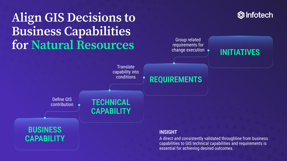
- A GIS strategy should start with decisions, not technology: Identify where location, terrain, subsurface conditions, proximity, or movement materially affects outcomes, then work backward to the enabling capabilities.
- GIS does not need to own every system or model; value comes from integrating authoritative information and inserting spatial decision support at the right point in the workflow.
- Capabilities create direction, but requirements and initiatives create action. Traceability from use case to gap to requirement keeps the roadmap business-aligned.
Impact and Result
- Prioritize GIS-supported decisions based on business value and define a clear contribution for GIS within each workflow.
- Establish the technical capabilities, dependencies, readiness gaps, and solution-neutral requirements needed to support selected use cases.
- Group requirements into independently executable initiatives and sequence them on an implementation roadmap.
About Info-Tech
Info-Tech Research Group is the world’s fastest-growing information technology research and advisory company, proudly serving over 30,000 IT professionals.
We produce unbiased and highly relevant research to help CIOs and IT leaders make strategic, timely, and well-informed decisions. We partner closely with IT teams to provide everything they need, from actionable tools to analyst guidance, ensuring they deliver measurable results for their organizations.
What Is a Blueprint?
A blueprint is designed to be a roadmap, containing a methodology and the tools and templates you need to solve your IT problems.
Each blueprint can be accompanied by a Guided Implementation that provides you access to our world-class analysts to help you get through the project.
Need Extra Help?
Speak With An Analyst
Get the help you need in this 3-phase advisory process. You'll receive multiple touchpoints with our researchers, all included in your membership.
Guided Implementation 1: Define Where GIS Must Support the Business
- Call 1: Scope requirements, objectives, and your specific challenges.
- Call 2: Select business capabilities for GIS support.
- Call 3: Define decisions, workflows, and GIS contribution.
Guided Implementation 2: Map the Required GIS Technical Capabilities
- Call 1: Map business needs to GIS technical capabilities.
- Call 2: Validate the capability map and add dependencies.
Guided Implementation 3: Translate Capabilities Into Actions
- Call 1: Generate and validate requirements.
- Call 2: Bundle requirements into initiatives.
- Call 3: Complete the GIS strategy executive summary presentation.
- Call 4: Review results and plan next steps.